Building Information Modelling
Maxwell GeoSystems' MissionOS provides its Clients with leading-edge Building Information Modelling (BIM) visualisation capability.
Get Data To Drive BIM And Communicate Works Progress And Performance In 3D. Remove Visualisation Uncertainties And Explore Spatial Relationships.
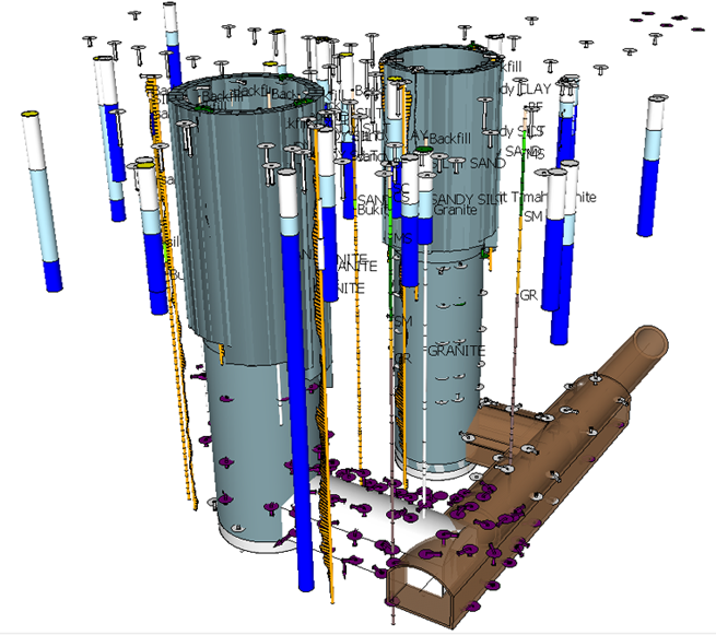
There is a significant move towards the use of BIM within construction. This starts during design and enables object characteristics to be added to 3D drawings, sequences to be worked out and schedules and BOQ items to be derived directly. Whilst this works at design time, during construction CAD staff are often hard pressed to keep up with the as built. The MissionOS contains all this data and is designed to track the project progress in real time. Once the data progress is digitised in the MissionOS the 3D shapes can be automatically generated and updated. As the figure below shows this can also include information about instrumentation results which may highlight pinch points or areas where stresses may be highest in the completed construction. These simple BIM components are created in real time for easy communication and for inclusion in larger models. Without the need for human intervention staff can be appraised on the latest status of the construction and understand all the interactions with the surrounding infrastructure.
Maxwell GeoSystems BIM models are created using Sketchup. Key advantages of Sketchup are the small and compressible size of the models files which facilitates sharing and the fact that the viewer is free to download, easy to use and familiar to most. The models can also be directly inserted into Google Earth as well as into corporate BIM environments such as MicroStation and Revit. The biggest benefit of Sketchup is that models can be constructed in code. BIM models can now be live documents updated automatically as the site information changes. The BIM provided by MissionOS conforms to a aspects of BIM level 2/3 particularly when considered specific to as built geometry and level 5 when considered in terms of movement records. With all BIM elements ultimately driven from the construction programme and auto generated this becomes a construction progress, planning and sequencing tool as well as providing added insights into the appropriateness of temporary works.
| Layer Element Type | Level 1 | Level 2 | Level 3 | Level 4 | Level 5 |
|---|---|---|---|---|---|
| Survey Level | Location/type | Alarm State | Displacement | ||
| 3D survey | Location/type | XY movement Z movement | Alarm State | Displacement | |
| Piezometers | Location/type | Water level | Alarm State | Change | |
| Inclinometers | Location/type | Movement at various depths Magnitude and Vector | Alarm State | Change | |
| Extensometers | Location/type | Movement at various depths Magnitude | Alarm State | Change | |
| Strain Gauges | Location/type | Strain/Stress | Alarm State | Change | |
| Load Cells | Location/type | Load | Alarm State | Change | |
| Distance gauges | Location/type | Distance | Alarm State | Change | |
| AGS Boreholes | Location/type | Record of geology and tests carried out | |||
| Tunnels/Shafts | Tunnel alignment | Individual adits | Coloured by tunnel parameters (from cycle file) | ||
| Piles, Barrettes and D walls | Pile location, dimension and depth | Type of pile | Rock vs soil embedment | ||
| Excavations | Divided into zones Location, depth | Records of progress | |||
| Struts | Locations, lengths orientations | Dimensions and type (equivalent area) | |||
| Ground surface/topography | Location, triangulations |
